Developing new paths for cycling in the countryside

Background
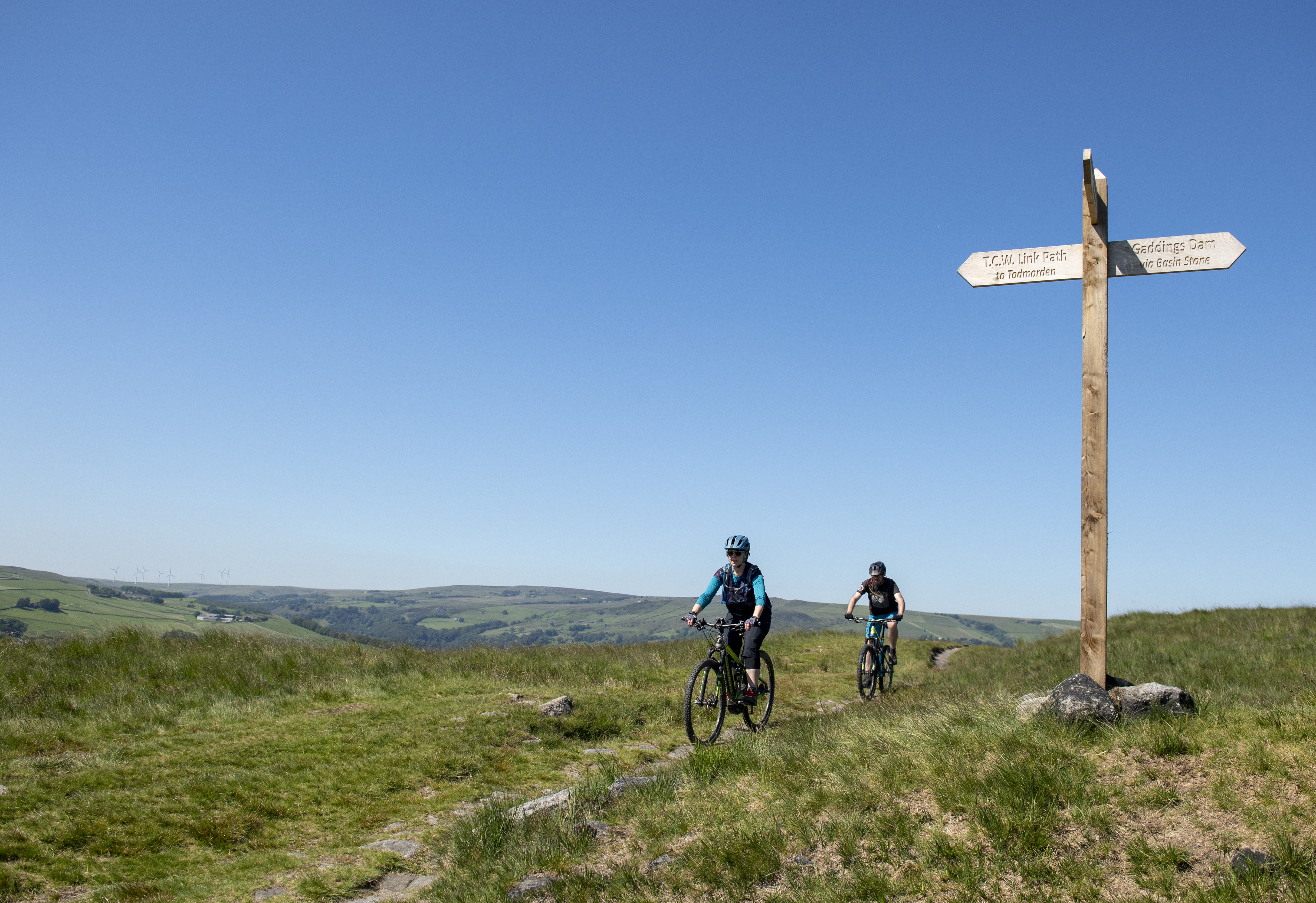
How to tell where cycling's legal
- Footpaths are open to walkers only (yellow waymarkings)
- Bridleways are open to walkers, horse riders and cyclists (blue waymarkings)
- Restricted byways are open to walkers, cyclists, horse riders and horse drawn vehicles (plum waymarkings)
- Byways Open to All Traffic (BOATs) are open to walkers, cyclists, horse riders, horse-drawn vehicles and motor vehicles (red waymarkings).
Additionally, cycle tracks and unsealed unclassified county roads (generally shown on OS maps as 'Other Routes with Public Access' or ORPA are legally classed as highways, but are recorded on the 'List of highways maintainable at public expense' and 'Street Works Register' rather than on the definitive map. The most accessible versions of this are via Find My Street and one.network.
The 'definitive map' shows all recorded public rights of way in an area, and is kept in each county or unitary council offices. Many are now available to view online. The maps were first drawn up in the 1950s, and authorities (except Inner London boroughs) have a duty to keep the map under continuous review (s53 Wildlife and Countryside Act 1981).
A route that isn't on the map could still be a right of way, however. And, just because a way is shown as a footpath, it doesn't necessarily mean that you can't cycle on it. It's vital that unrecorded ways are added to the map to protect current and future use.
Cyclists are usually most interested in the addition of bridleways and restricted byways. (The establishment of new BOATs has been severely curtailed by the Natural Environment and Rural Communities Act 2006).
Expanding the rural path network for cycling
At the moment, only about a fifth or so of the public rights of way network in England and Wales is available to cyclists. Access to land in Scotland is much more widespread, due to the Land Reform (Scotland) Act 2003, which gives the public (including cyclists) lawful access to most land and inland water there, provided they comply with the Outdoor Access Code.
Cycling UK would like to see the Government in England adopt and adapt Scottish-style access laws, but in the meantime, there are a number of options for developing more countryside routes for cycling in England and Wales - some of them much better and more workable than others.
Basically, the options fall into two categories:
- By statute (i.e. applying the law); or
- By gaining the landowner's permission.
Cycle dedication via statute:
1. Conversion under the 1984 Cycle Tracks Act
This is limited to the conversion of public footpaths only and is only appropriate if the path is wide enough for cycling. It is sometimes opposed by walkers, who may be reluctant to share the route with cyclists. Also, once a path becomes a cycle track it no longer appears on the definitive map.
The strong possibility of objections to proposals for converting a footpath into a cycle track - and the fact that this might well lead to a time-consuming public inquiry - make this process unpopular with many highway authorities. However, the Government has at least looked at simplifying the bureaucracy involved as part of the 'Red Tape Challenge' (c2011-2013).
See our campaigns briefing on public footpaths for more.
2. Creation
As mentioned above, local authorities can create new rights of way, or they can make a creation agreement with the landowner. When creating a way, the authority should update the definitive map, but even if they don't, the creation order/agreement, is evidence that the way is a public right of way.
a. Creation Order by a highway authority (s26 1980 Highways Act)
By this, the highway authority creates a bridleway or restricted byway and pays compensation to the landowner. As it’s expensive, it is not commonly used.
b. Creation by agreement (s25 1980 Highways Act)
By this process, a bridleway or restricted byway is created following discussions between the highway authority and a sympathetic landowner, without compensation.
3. Dedication
a. Deemed (or presumed) dedication through 20 years of cycle use (s31 1980 Highways Act)
The landowner is 'presumed' to have dedicated the trail as a right of way on the basis of (usually) 20 years uninterrupted use by the public. Anyone can claim such ways by showing evidence, either documentary (such as photos and documents) or anecdotal (such as witness testimonies) that the way has been used continuously during the required period.
Thanks to s68 of the Natural Environment & Rural Communities Act 2006, cyclists can now make claims based on uncontested cycle use. If successful, this leads to a restricted byway.
b. ‘Express dedication’ as bridleway or carriageway (Common Law)
Campaigners, clubs or individuals negotiate the route and consequent compensation with sympathetic landowners. Once dedicated, the route becomes a highway, but may not necessarily be later adopted for maintenance by the highway authority. This system has resulted in some 80 new bridleways in the Mendips negotiated by the Trails Trust.
c. Dedication by the landowner (s16 2000 Countryside and Rights of Way Act (CRoW)
A landowner can dedicate a path or area for cyclists through this provision, but we are not aware of any such dedications to date. Any such dedicated path or area would not become a highway and therefore would not be maintainable by the highway authority.
d. Dedication by a Parish Council (s30 1980 Highways Act)
This creates a bridleway or restricted byway by agreement with the landowner. It is rarely, if ever, used.
3. Recording under s53 1981 Wildlife & Countryside Act
This is instigated when a highway authority becomes aware of evidence that a definitive route for cyclists may exist and should be on the definitive map. Evidence is typically based on user testimonies, enclosure awards, tithe maps, railway and estate maps and Finance Act maps, amongst others. The process is, however, very bureaucratic (see below), and with a typical output of around five Orders per authority per year, backlogs of ten years are not uncommon.
Claiming an unrecorded right of way
Why?
A way that is recorded on the definitive map is protected for existing and future use and it is easier to stop anyone interfering with it. Also, if you've been challenged for using a path (e.g. by a landowner, a 'keep out' sign, or locked gate), if it's not on the map, you may lose your right to ride on it.
Under the Countryside and Rights of Way Act 2000, historic rights of way which existed before 1949 and have not been added to the definitive map by 1 January 2026 will be extinguished and the public right to use them will be lost. It's crucial that these lost ways are recorded before the cut-off date.
There are two basic methods to make a claim. They can be used together and the relevant highway authority will be able to guide you through the process in detail.
1. s53 Wildlife & Countryside Act - historical evidence:
You will need to use the local Public Records Office to find historical evidence that the route should be, say, a bridleway (which means that it's legal to cycle on it).
and/or
2. s31 Highways Act Deemed Dedication following 20 years of cycle and/or equestrian use:
Basically, you'll need to compile evidence that the path has enjoyed uninterrupted use by cyclists for (usually) 20 years. Although most authorities tend to accept claims if at least half a dozen witnesses can testify to this, it is best to gather as many testimonies as you can. All relevant landowners have to be notified, a step that might prove complicated and involve Land Registry searches. If you can't find out who the owner is, you could ask the council to put up a notice on the land.
Applying to have the definitive map modified
The first step is to go to the relevant local authority's office to check the existing definitive map to see if the way that interests you is on it and, if it is, what its status is. If it's not there, or you disagree with its recorded status (e.g. it's listed as a footpath, but you think it should be a restricted byway), ask the authority to check.
If you think the map and/or the authority is wrong, and you want to take the matter further, you can make an official claim by applying for a 'definitive map modification order' (DMMO).
The relevant highway authority will be able to guide you through the process in detail and explain what sort of evidence you need to supply.
When you're happy that you've done everything required of you, you can submit your claim. The authority then has to investigate and apply statutory tests to it. If all goes well, the authority will make the Order and advertise it, giving the public a chance to object. If you think the authority hasn't made the right decision based on the evidence you've supplied, you can appeal against it.
Objections to the Order
Anyone may object (but only on relevant grounds). If there are no objections, then the authority should confirm the Order and record the way.
If there are relevant objections, the matter must be referred to the Secretary of State for Environment, Food and Rural Affairs (or the Welsh Assembly in Wales), although in practice this is dealt with by a Government agency, the Planning Inspectorate, acting on their behalf.
The Inspectorate appoints an inspector, who decides whether to hold a public inquiry, or to ask for written representations. This is usually decided on the basis of the number of objectors; the more objectors, and the more complicated their objections, the more likely that the case will be decided through an inquiry. In either case, the Inspector will visit the site in question.
Inquiries
If the inspector decides on an inquiry, it should be held on a convenient date for everyone and near the trail. You'll be invited to submit proof of evidence and the process, including the timetable, should be properly explained to you.
Objectors and applicants are permitted to employ professional representation and to cross-examine witnesses.
Sometimes, the evidence points towards a right of way with a different status from the one advertised in the Order: for example, a claim submitted by horse riders for a bridleway may find support from cyclists or carriage drivers, indicating that the way ought to be a restricted byway. The inspector can modify the Order, but must then re-advertise it and invite objections. This could make a new inquiry necessary.
The inspector considers the evidence and makes his decision, after which there is no right to further inquiries or representations. It is, however, possible to challenge the decision through the courts.
If the decision goes in your favour, the authority should automatically make the modification to the definitive map.
Note: Under the Countryside and Rights of Way Act 2000, no historic paths can be added to the definitive map after January 1 2026.
Permissive options
Adding to the routes available for cycling can also be done via 'permissive' options, as opposed to the statutory processes listed above. They are often considerably faster to implement, but permission may be withdrawn at any time.
1. Informal permission by landowner
Cycle use permission can be obtained by word of mouth, but signed, written confirmation is preferable. Some larger landowners may provide such informal access as a result of their access policy, as in the use of stone tracks in freehold Forestry Commission Woodlands.
2. Deed of agreement by the landowner
This is a more formal alternative to an informal agreement, and is likely to be between landowner – either the local authority, utility or other private landowner – and a representative body such as a cycling organisation, cycle club or community group. The agreement may well include arrangements for maintenance and management of the trail. The resulting route would not be recognised as a highway in law – it's just a way open for cyclists.
3. Access for cycles as part of a commercial enterprise
This can be found in a number of forms:
- Payment of an entry fee to an estate or woodland area
- Permit fee for a trail network
- Free informal use of a trail network with income derived from car park, café, visitor centre, cycle shop or cycle hire facilities
4. Defra / Natural England Higher Level Stewardship (HLS) Scheme
This scheme gave landowners grants for agreeing to permissive bridleways for use by cyclists, usually as part of a wider environmental project. EU rules have now stopped revenue funding for any new examples, although current schemes will continue to the end of their ten year agreements.
Further reading
- Cycling UK's campaigns briefing on Bridleways, Restricted Byways and Cycle Tracks explains these ways in more detail, and our campaigning views about them
- Cycling UK's campaigns briefing on Changing the Status of Rights of Way explains our views on statutory orders and why and how to get the best out of the process for cycling.
- Cycling UK's campaigns briefing on Off-road Access in Scotland explains our views on the Land Reform (Scotland) Act 2003, which has been highly beneficial to cyclists
Popular content
Further reading