The Beeching betrayal: how can we reclaim our lost railway lines for cycling?

On 27 March 1963 the infamous Beeching Report was published, leading to the closure of more than five thousand miles of ‘uneconomic’ railway routes. In the immediate aftermath of the report, Michael Dower, a chartered surveyor and town planner, and son of John Dower, who wrote the 1945 White Paper "National Parks in England and Wales" (which led to the National Parks Act of 1949) wrote a paper for the Architectural review.
In this article, Dower highlighted the potential value of these routes, and the canals, as a network of recreational long-distance routes spanning the countryside and connecting towns with the surrounding countryside. he coined a name for these routes, Green Ways, and suggested that they could be formally designated as long-distance routes (now called National Trails) as a way of retaining their benefit for the public. He further suggested that….
“Touring cyclists are kin to walkers in their needs. The Cyclists Touring Club alone has 24,000 members. They want to get into the country quickly and to find routes away from heavy traffic but with ready access to places of interest.
“They welcome easy gradients and a good cycling surface, which need not be more than well-drained beaten earth. At present, for lack of cycle routes, they are forced to suffer main-road traffic in getting out of town.
“Once in the countryside they may dodge along local roads but a good ‘trunk’ network of cycleways would give them the choice between this meandering and a more speedy passage, and might even be useful to the ‘Rough Stuff Fellowship’, whose 2000 or so members cycle to the top of Helvellyn and other unlikely places and might be glad of direct routes from town to mountain foot.”
Seems pretty prescient to me…
Following the original proposals, an extensive report produced for the Countryside commission in 1970 looked in detail at the problems created by the Beeching Closure and the sale of rail estate. The report identified that British Railways was under pressure to sell off disused railway land as quickly as possible, and that as a result, the system in place for disposing of disused railways had failed to “ensure that the land was put to the most advantageous use in the public interest as a whole”. The report also laid criticism at the door of local authorities for often failing to see, and act on, this potential:
“It is true that the option of purchase goes first to the County, Borough and District Councils, but the action taken in Council Offices generally seems to amount to an enquiry as to whether the land is needed for any specific purpose by any department of the Council (e.g. County Surveyor, Chief Education Officer, etc.).
“If not, the offer is rejected and the process of sale may continue. Unless the Councils set themselves up as the custodians of general public interest, genuine projects thoroughly deserving of consideration may be prejudiced.”
A whole variety of successful alternative recreational uses for disused lines had been identified and suggested in this report, from use as bridleways and cycle tracks through to linear country parks, campsites and nature reserves. Regrettably, all too often, this failed to happen. Some positive examples were seen, for example the ‘Tissington Trail’, where the Peak District National Park planning board acquired about 11 miles of track, including five stations and seven cottages for a little over £2000 (equivalent to around £50,000 allowing for inflation) while the ’Wirral Way’ in Cheshire saw a 10-mile stretch of line developed into a linear country park (at the time, up to 75% central government grant-aid was available for the acquisition and setting out of new country parks).
The report urged the Minister for Housing & Local Government to set up a working body to look again at the mechanism by which disposal of this land was tackled, and, at the very least, to require consultation with the countryside commission at an early stage prior to considering disposal. However, it seems that little was changed, and as a result, many potential green-way routes were lost through being sold off piecemeal.
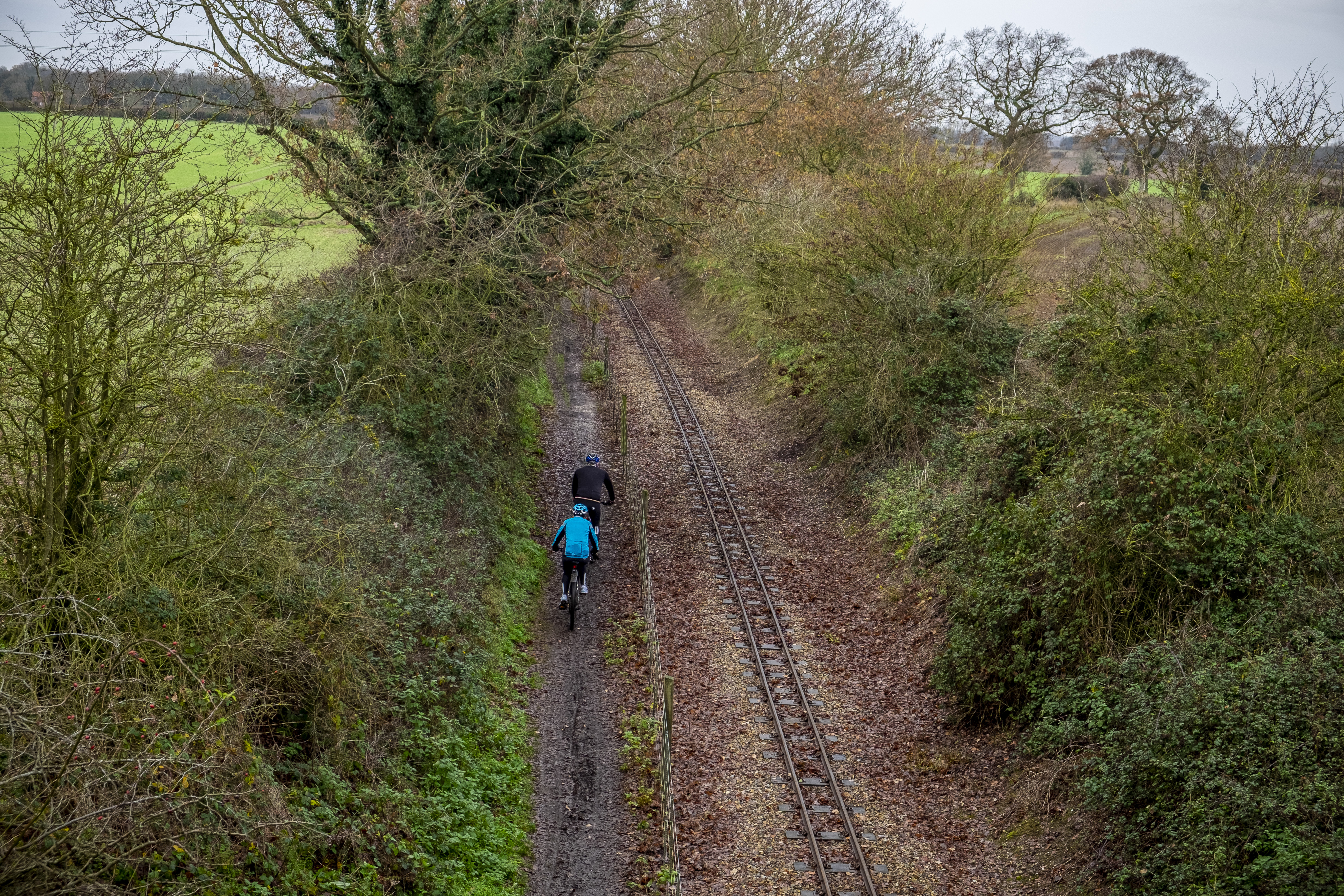
The result of this was a fragmented network that has been almost impossible to piece back together. Sections of route that could be opened to the public cannot be used because they don’t connect to each other, and long stretches of usable route become interspersed with detours onto busy roads because a short section is owned by someone else, a problem we explored in our video on the Great North Trail:
The Millennium bug
In the late 1970’s, Cyclebag, later Sustrans, formed in Bristol. Over the coming years their success in developing remaining disused railway lines as multi-user routes can only be described as remarkable. By the 1990’s, Sustrans had a growing following and influence. Their development of selected routes in mainly urban areas seen as having real potential for promotion of sustainable travel, and money from the National Lottery Millennium Fund and similar pots of money greatly accelerated their work, as they sought to develop the National Cycle Network.
However, there is also little doubt that even with this work, very significant gaps remain in the network, the impact of the historic route sell off has proved to be extraordinarily difficult to reverse, and reluctance by local authorities to use statutory powers, allied with complexities in the rights of way system and growing costs has led to almost complete stagnation in expansion of this network, particularly in rural areas.
Even if we disregard the issues of long disuse and lack of maintenance of railway structures, The wall of bureaucracy to opening up routes can often be bewildering. Whilst wildlife designations and protected habitats such as bat colonies in tunnels are clearly valid considerations that need careful management, the more mundane obstructions placed in the way by planning departments and landowners have delayed many routes significantly.
At the same time, in some cases criticism also needs to be placed at the door of our own community - cycling is, of course, a broad church, with a variety of issues where reasonable people can disagree on the best solutions, but speaking to a regular basis to rights of way officers and national parks staff, I am also aware that in some cases, expectations for urban levels of surfacing and even lighting in rural areas and protected landscapes have led to opposition from groups who should be our friends.
We have also witnessed cycle groups seek to exclude horse-riders or make demands for application of guidance such as LTN 1/20, a predominantly metropolitan urban cycle infrastructure standard, and the result has, in some cases led to projects being abandoned or delayed due to cost and complexity. Of course, It's right that we should expect high standards, but there are cases where those standards are being used against us to oppose cycle infrastructure and shared use, so there may be a risk that our commitment to ‘cycle infrastructure’ overrules the principles of multi-user access in areas where the *context* (and that’s a really important word here) of individual routes is predominantly rural leisure use rather than utility and commuting.
Perfection can sometimes be the enemy of the good, and there is an argument that it may often be better to get it to a bridleway or forest road standard in order to open the route for use rather than witness routes remain closed due to resource implications (though clearly, a complete rebalancing of funding for rural cycle routes is needed, with a greater share of the highways budget and resource from agri-environment schemes like Environmental Land Management Schemes in order to incentivise landowners and deliver permanent, rather than short-term permissive, routes.
How could we begin to turn the tide
The recent pandemic has highlighted the importance of access to nature for our health and wellbeing. The Environment Agency has said that the NHS could save billions of pounds annually in treatment costs if everyone had access to good quality green space.
We need to deliver real alternatives to the increasingly overcrowded and dangerous road network, which all too often offers the only route between our towns and outlying rural communities. In some places, the best solution will be the creation of new segregated infrastructure running alongside existing roads, whereas elsewhere there will be opportunities to create safe, convenient and attractive off-road routes, well away from traffic, for both active travel and recreational use.
With the right will, existing rights of way National Trails legislation could be used far more effectively to expand genuine multi-user access opportunities, both to access land and by opening up disused railway lines, allowing people to walk, cycle and ride horses both to, and through, our most special national landscapes.
Recently, a clarion has been raised by campaigners seeking to extend open access and permit other activities such as wild camping. The Labour Party have already committed to extending the ’right to roam’, hopefully other parties will follow suit in their own manifestos.
It’s vitally important that any future reforms should create a clear presumption in favour of multi-user access to rights of way and (at the very least) sustainable routes on access land. We do, of course, need to carefully balance the potential impacts of recreation & access to the countryside against land management and conservation priorities, to respect and leave space for nature (even though these things are not always in conflict, a concept already long established in our National Parks through application of the Sanford Principle). Nobody is arguing for a 'free for all’, in fact I think that is the last thing that many of us would want, but there in a huge opportunity to identify those areas where access rights could be extended to offer greater provision for horse riding, mountain biking, wild camping and swimming/canoeing.
These reforms should also involve overhauling the processes for creating and recording of public rights of way. The current process is costly, ineffective, and mired in bureaucracy - it can take years to process a single claim for a right of way and the backlog of historic routes, missed during the original creation of the definitive maps, is already so extensive that it could take decades to resolve (any new legislation should also repeal the 2026 cut off-date for the recording of historic routes). There is also a strong argument that cycle tracks, which are not currently shown on definitive maps, should be included in the rights of way process in order to offer greater protection and secure their future for future generations.
Finally, there should be a ‘right to apply’, enabling local communities to put forward new rights of way where they would be beneficial for local residents or visitors. In the same way that they can currently do by identifying assets of community value. This would clearly be of benefit for reopening disused railway lines to reset the damage caused by the failure to secure these routes for public use in the past.
Popular content